
Strong winds and heavy rain to hit East and North Yorkshire from Friday to Sunday
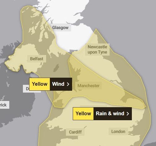
The Met Office has issued a yellow weather warning for rain and wind which is expected to hit East and North Yorkshire between Friday and Sunday.
The warning will be in place from 3pm on Friday until 6am on Sunday, when strong winds and heavy rain have the potential to lead to some disruption.
In Driffield and the Wolds, rain is expected on Friday evening into Saturday morning and throughout Sunday.
Winds will reach high speeds of 46mph on Sunday.
Those living in the area covered by the warning are being told to expect the following:
– There is a small chance of longer journey times or cancellations as road, rail, air and ferry services are affected
– There is a slight chance of some damage to buildings, such as tiles blown from roofs
– There is a small chance that homes and businesses could be flooded, causing damage to some buildings
– Spray and flooding could lead to difficult driving conditions and some road closures
– There is a slight chance that power cuts may occur, with the potential to affect other services, such as mobile phone coverage
– There is a small chance that injuries and danger to life could occur from large waves and beach material being thrown onto sea fronts, coastal roads and properties
– There is a small chance that some communities will become cut off by flooded roads
– There is a small chance of injuries and danger to life from flying debris
– There is a small chance of fast flowing or deep floodwater causing danger to life
– There is a small chance that some roads and bridges could close
A deep low may cross England and Wales from Friday afternoon, clearing to the east Saturday night. The low may bring a period of strong winds to much of the warning area, with some heavy rain likely to the north and west of the low centre, and some hill snow in the north, above around 200 metres.
Around 15-25mm of rain may fall quite widely, more particularly across central, northern and western parts of England and Wales, with exposed higher ground in the north and west, particularly parts of Wales, which are at greatest risk of seeing flooding impacts, perhaps locally seeing closer to 50-70mm.
Winds may quite widely gust to around 40-50mph inland but locally could gust in excess of 60 mph, whilst around coasts, winds may gust to 60-70mph, perhaps locally nearer 80mph.
The wind and rain may cause disruption to travel, with difficult driving conditions likely.


